
Satellite imagery for global solutions
Airbus Defence and Space’s SPOT multi-mission platform series, initially designed for the French space agency, CNES, is now used for many European Low Earth Orbit Earth observation satellites, including the Helios military reconnaissance satellites, the ERS radar satellites, the Envisat Polar Platform and the polar-orbiting MetOp spacecraft.
All five SPOT satellites were built under the prime contractorship of Airbus Defence and Space, responsible for the platform and high-resolution imaging system on all Spot satellites. SPOT 1 was launched in February 1986. Two SPOT satellites are currently in operational use, allowing a daily observation of virtually any point of the globe at a 10-metre resolution. SPOT 5 (launched in 2002) provides 2.5 metre resolution images over a large swath.
Airbus Defence and Space also financed, jointly with CNES and Spot Image (now fully integrated into Airbus Defence and Space), the high-resolution stereoscopic instrument HRS flown on SPOT 5. HRS generates digital elevation models for 3D mapping applications.
Airbus Defence and Space’ GEO-Information Division is the worldwide distributor of global imaging products and services derived from SPOT satellite data.
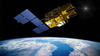
To ensure long-term continuity in high-resolution data while competition gets ever tougher, Airbus Defence and Space decided in 2009 to launch a new project with private financing, AstroTerra. This aims to put the SPOT 6 and SPOT 7 satellites into orbit, guaranteeing smooth transition for the SPOT family.
SPOT 6 was launched in September 2012 by a PSLV launcher from the Satish Dhawan Space Center in India.
The new-generation SPOT 6 & 7 Earth observation satellites will offer optical medium resolution and wide swath capabilities. Airbus Defence and Space, as prime contractor, is responsible for the complete development of the AstroTerra system including SPOT 6, SPOT 7, the Control Ground Segment and the Exploitation Ground Segment.
| Airbus Group | |
|---|---|
| Product Category | Satellites |
| Product Number | SPOT |
| Product Name | Earth Observation Satellites |


